FROM THE ARCHIVES
Looking Back
I wrote this paper during my years with the Central Water Commission, together with my colleague D.P. Mathuria. We were examining why the Kosi continued to pose such a difficult flood-management challenge despite more than a century of engineering attention.
Reading it again after many years, what interests me is not only the Kosi. I can see here an idea which has stayed with me in much of my later work—the danger of looking for one technical solution to a complex system without first understanding how that system behaves.
I am therefore republishing the paper substantially as it was written. Some data, institutional references and engineering proposals naturally belong to the period in which it was written. I have retained them because this is an archival piece, not a contemporary assessment of the Kosi basin.
Original Paper
1. Awadhesh Kumar Jha,
Deputy Director,
Central Water Commission,
Sewa Bhawan, R.K.Puram, New Delhi-110066 ( jha_k3@hotmail.com)
2. D.P.Mathuria,
Deputy Director,
Central Water Commission,
Sewa Bhwan, R.K.Puram, New Delhi-110066 ( yourdp@yahoo.com)
Abstract
Kosi, known as River of Sorrow in Bihar, is one of the largest river of India. It has a notorious tendency of shifting its course due to heavy charge of silt/sediment. Kosi river has shifted from east to west over 114 km from 1739 to 1950 (CWC, 1981). It implies that Kosi has been shifting at the rate of 0.54 km per year on an average. Due to shifting of river, it forms numerous Dhars, with the result built up property and other vegetations are destroyed which finally causes immense suffering and the instability of life. As per one report, about 8000 sq. km. of lands in Nepal & India had been laid waste as a result of this shifting. This paper has attempted to present the genesis of recurring Kosi flood by making a review of various publications, books, reports and suggest some tangible solution to this perennial problem. It would be naïve to embark upon finding a solution of this menace through structural measures in the form of High Dam without understanding the characteristics of flood in general and Kosi river in particular.
In the past various solutions have been attempted to be found out since 1935 Patna Flood Conference to 1953 CWPC proposal of constructing a Barrage along with Flood Embankments. In all these conferences and proposals the central focus has been towards structural measures for containing the Kosi flood. Of course, the Hanumannagar Barrage & embankments built few decades ago temporarily helped to check the lateral shifting of the Kosi and putting the river into a definite channel. But, at present the pond of the barrage at Hanumannagar is almost full of sediments. Soon the embankments would be ineffective to control the Kosi floods.
After review of the various books, publications, references, this paper attempts to remind the practicing Engineers to adopt a multipronged strategy of tackling Kosi flood. This would include construction of Kosi High Dam in Nepal as immediate solution. At the same time we should change our mindset and in order to find a long term solution to this problem we should allow the river Kosi to flow in a manner, condition, size and pattern which would minimize, if not totally eliminate, the eroding characteristics of the channel/river and oscillating trend of it. This requires patience and perseverance by diligent studies for understanding the texture, structure and behavior of the river over a number of years.
Understanding Kosi Flood Problem
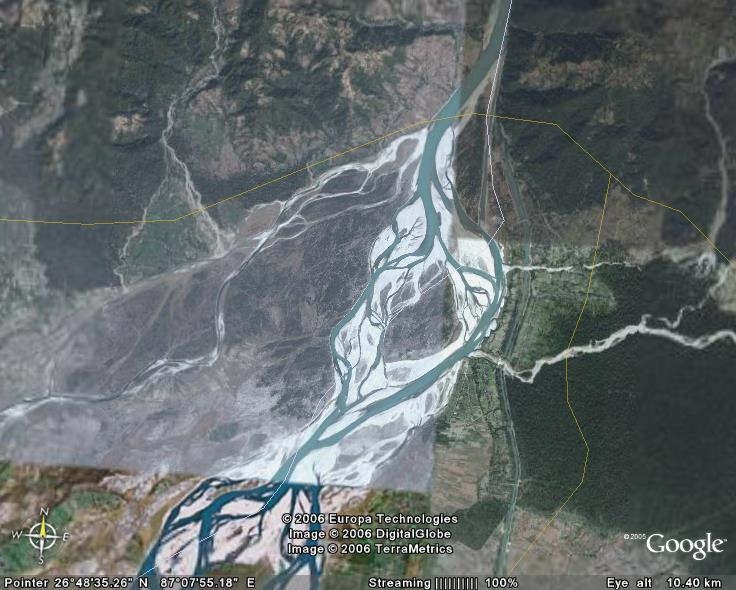
The Kosi River is known as the river of sorrow of Bihar. The Kosi River emerges from Chatra gorge (Nepal) into the alluvial plain with a large volume of water during rainy season and is sometimes subject to rising of water level over 10m in 24 hours in the gorge. It also carries huge quantities of silt and sediment, with the result that large islands are heaped up by the deposition of coarse sand on fertile agricultural and cultivable lands, making them barren for long periods. In 1941, Sir C.C.Inglis, Director of Central Water and Hydro-Dynamics Research Station, Poona identified the Kosi problem as being due to excess charge of the sand that Kosi water carry. Kosi river has shifted from east to west over 114 km from 1739 to 1950 (CWC, 1981). It implies that Kosi has been shifting at the rate of 0.54 km per year on an average. Due to shifting of river, it forms numerous Dhars, with the result built up property and other vegetations are destroyed which finally causes immense suffering and the instability of life. As per one estimate, about 8000 sq. km. of lands in Nepal & India had been laid waste as a result of this shifting. The figure-1 depicts the image of river Kosi and its various dhars.
Therefore, the main problem of Kosi is to check the flow of coarse and medium silt and to confine the river to a definite channel and prevent its lateral movements. Fortunately, the Hanumannagar Barrage & embankments built few decades ago temporarily helped to check the lateral shifting of the Kosi and putting the river into a definite channel. But, at present the pond of the barrage at Hanumannagar is almost full of sediments. Soon the embankments would be ineffective to control the Kosi floods.
It is predicted that the Kosi would again take its 1732 course. The farthest position of the new course of the Kosi is expected to be about 120 km away from its present course. The swing of the Kosi river to the east could be sudden and almost unexpected because nobody yet exactly knows when it is going to happen. The people would be completely taken by surprise. So the loss of life could be very high. In a similar type of 1938 flood incident of the Yellow River in China the number of people killed alone was about half a million. It does not need to be further explained that such shifting of the Kosi to the east would be a biggest disaster for the whole region. Mr. F.A. Shillingford, an expert on Kosi, had warned a longtime ago in 1893 that the eastward movement of the Kosi will be in one big swing accompanied with great loss of life and property. To understand why Kosi abandon its course, we need to delve into the characteristics of Kosi.
Characteristics of River Kosi
The past history of Kosi is the history of different courses which it adopted in successive years below Chatra. In fact, the oscillation of Kosi below Chatra has been compared with that of a pendulum of a clock having its focus at Chatra and district of Purnea on the east & district of Darbhanga on the west being two extremes of oscillation.
It is generally believed that Kosi was flowing far east of its present course. There are two theories regarding the original course of the Kosi, viz., (i) that it joined the Brahamputra and (ii) that its former channel was the one now occupied by the Karatoya, a river in Bengal. There is, however, no sufficient evidence in support of the suggestion that the Kosi joined the Brahamputra, yet the second theory seems more probable as it has been put forward by Mr. O’ Dounell in the Bengal Census Report of 1891 where he has written, ” the Karatoya in the days of its real greatness was the bed not only of the Teesta, but of the Kosi and of the numerous hill – streams which now unite to form the Mahananda”. The belief of the local people suggest that in bygone time the Kosi used to join Mahananda through the river Parman (also called the Panar) near Araria in Purnea District. There is a long stretch of depression varying in width from 30m to 60m passing from Forbesganj side towards Araria and further south, which the local people believe to have been at one time the course of river Kosi.
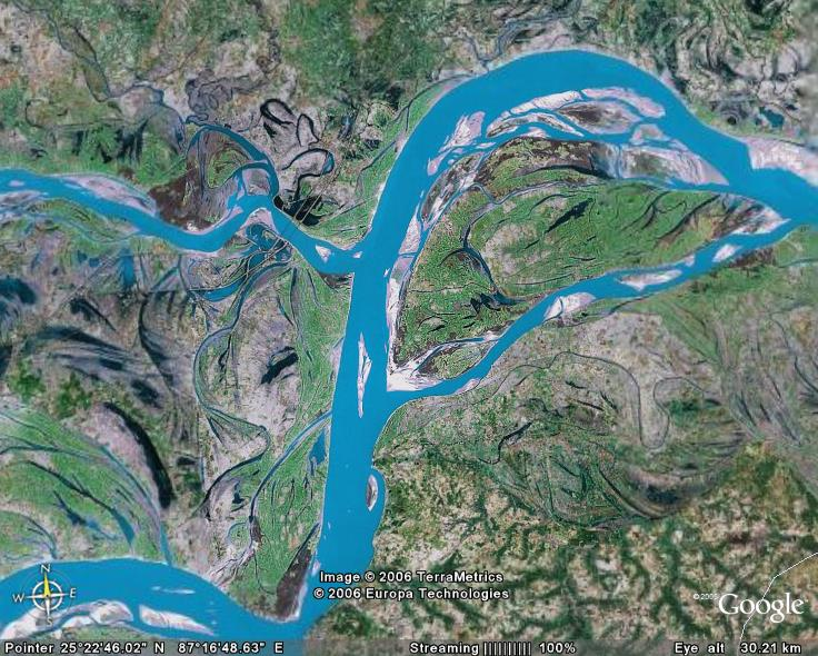
The Kosi has been reportedly flowing through various Dhars ranging from Kali Kosi in 1731 to present course. The general characteristics of Kosi have been vividly described by Mr. J. Inglis as follows:
“The main stream flows with a swift milky flood dividing the two great indigo and rice districts of Bhagalpur and Purnea. When swollen by the melting of the snows or by the annual rains, the river overflows its banks, and at such times presents the appearance of a broad swiftly flowing sea. In the dry season the waters are confined to innumerable channels, some so shallow that the stilted plover can wade across and others running deep and strong with a ceaseless gurgling swish that would sweep the stateliest elephant off its feet and carry its ponderous bulk for down the stream. These streams seem to run at random over this deltaic plain cutting diverging here reuniting there, forming a wide bend at one place, and are cutting direct through the sandy soil in another. The face of the country is split up into infinitude of islands, and recticulated everywhere by a network of dry channels and shifting sand banks, and over all wherever there is inch of soil the stately elephant grass spreads its feathery mentle.”
Mr. F.A. Shillingford wrote in the Journal of the Asiatic Society of Bengal for 1985 that the bed of Kosi oscillates over a vast tract of country from the Brahamputra to near the mouth of the Gandak, the oscillation being repeated at long intervals of time. This gets corroborated from the following Sanskrit verse written by Great Maithili Poet Vidyapati, describing the extent of Mithila:
" GANGA BAHTI JANIK DAKHIN DISHI, PURBA KOUSHIK DHARA, PASCHIM BAHTI GANDAKI, UTTAR HIMAWAT SHAIL BISTARA, KAMLA, TRIJUGA, AMRITA, DHEMRA, BAGMATI, KRITSARA, MADHYA BAHTI LAKHAN PRABHRITI, SA MITHILA VIDYADHAR."
Causes of Abandonment of Course by River Kosi
Kosi River brings every year an enormous quantity of sediments from its catchments in the mountains. Sir Claude Inglis an expert on Kosi had attributed the shift of the Kosi River channel to excessive sand load carried by the river. Leopold and Maddock considering Kosi behavior had stated that a braided stream will tend to shift laterally at a rate dependent on the rate of accumulation of material being deposited. As one course becomes higher than possible adjacent paths, the river would shift (Thapa, 2006). Mr. C.C.Inglis reported once: “Translation of the Kosi is normally started by spill from the outside of a bandh entering a small natural drainage. Such drains tend to form wherever surface drainage is concentrated, which occurs wherever surface flow is interfered with by road or embankment.”
Past Attempts to Solve the Problem of Kosi
The first attempt to tackle the problem was made in conference in 1896-1897 in Calcutta when the question of building extensive embankments to control the river and prevent its swinging to the west was considered. The conference was presided over by Secretary to Government of India in the P.W.D. However, the proposal was considered to be of doubtful efficacy and it was concluded that no steps were feasible for controlling the course of this big river with its numerous channels and their wide and elevated beds, beyond protesting by short lengths of embankments isolated tracks exposed to its floods.
1. 1937 Patna Flood Conference:
In November 1937, a conference of officials and non-officials was called by the then Provincial Ministry of Bihar to discuss the problem of floods in North Bihar. At this conference the controversy centered mainly round ‘embankments’ or ‘no-embankments’. The deliberations of this conference, however do no appear to have led to any constructive approach towards the solution of the flood problem of North Bihar.
2. Claude Inglis’s Report
In 1941 Mr. C.C. Inglis, Director, Central Irrigation and Hydro-dynamic Research Station made a comprehensive inspection of Kosi river both in Nepal and Bihar and submitted a report on the ‘Factors affecting the westerly movement of the Kosi river with suggestions for further investigations’. His conclusions were:-
(i) “The river is now held firm along the right bank and will continue to fill up the trough of low land which is now occupied by the Tiljuga and Balan rivers, until its westward translation is stopped by the somewhat higher land running south from Tamuria, along which an embankment will probably be required to prevent still further westward movement”.
(ii) “The cause of the movement is the building up of the submontane delta due to an excess charge of sand. This sand is stated to be due to a considerable extent of landslides and erosion which occur as a result of removal of forest trees and undergrowth from the steep hillsides in order to secure short term cultivation”.
He wanted some more data to be collected for the lower reaches of the river but no action was taken by the Government on his report.
3. The Bihar Post War Development Plan
Owing to shortage of personnel and equipment during the war years, no further action seems to have been taken in dealing with the problem of the Kosi beyond including in the Bihar post-war plan a proposal for the construction of marginal embankments, right from the Nepal foot-hills to the Ganga, to control the river by confining it to a definite channel. The scheme was estimated to cost roughly about Rs. 10 crores.
4. Report of the Central Waterways, Irrigation and Navigation Commission (1946)
The above proposal of marginal embankments was considered by the Labour Department of Government of India, and the Secretary referred it to the Chairman, the then Central Waterways Irrigation and Navigation Commission (now Central Water Commission), who opined that a more effective control would be secured by the construction of storage reservoir in the hills which would give effective control of floods in the river and in addition, provide water for use in irrigation, navigation, power generation etc. As a result of correspondence with the Government of Bihar, a further note, was recorded on the 29th August, 1945, to the effect that “no satisfactory scheme for the control of the Kosi and its flood damage can be prepared except after a comprehensive survey of the entire field of possibilities viz. the construction of a high dam across the Chatra gorge, training the Kosi in the lower reaches and exclusion of floods from the low lying areas which are susceptible to water logging”.
5. The Original Multipurpose Scheme (March 1950 and June 1950)
Thus though the problem of the Kosi had been engaging the attention of the authorities since a long time, the work of surveys and investigations for the purpose of preparing a project for the control of this dangerous river, which has rightly been called the Sorrow of Bihar, was only started in the year 1946. As a result of these surveys a multipurpose scheme costing Rs. 175 crores was evolved which comprised the construction of:
a) A dam, at Barahkshetra, of an unprecedented height of 269 m above foundation rock to impound 8507 million cubic meter in the reservoir of which 3822 million cubic metres was dead storage to provide silt reserve and minimum head for power generation, the remaining 4685 million cubic metres providing flood absorption capacity to regulate floods so as not to let them exceed a safe maximum of 5660 cubic metres to generate hydro-electric power to the extent of 1.8 million kilowatts, and to provide navigation facilities in the reservoir and the river below.
b) A barrage at Chatra and canals for irrigating annually 15.55 lakh hectares in Nepal and Bihar, flushing drainage channels and siltation of low lying areas and for generating 90,000 KW hydro-electric power on the eastern canal.
In view of the huge cost of the project and the limited financial and material resources available in the country, the scheme was divided into seven easy stages, each self-supporting and independent in itself and yet capable of being superimposed on the preceding one without involving any engineering difficulties or wasteful expenditure.
6. Advisory Committee Report (1951)
When the report on Stage I of the above multipurpose scheme was submitted to the Government of India for sanction, they vide Resolution No. DW-21 dated 5th June, 1951, appointed an Advisory Committee consisting of five Engineers to go into details of the Project and to advice them on the general soundness of the scheme, on its adaptability to staging and as to the economics of the project as a whole. The committee submitted their report in September, 1951 suggesting certain modifications and recommended the construction of Belka dam with FRL 115.82 m.
The Belka reservoir was planned to impound 2158 million cubic metres of water of which 962 million cubic metres was to be dead storage to provide silt reserve and minimum head for power generation, the remaining 1196 million cubic metres providing flood absorption capacity for regulation and moderation of floods. The dam was to have a maximum hydraulic height of 25.91 m.
a) The Committee recommended further the construction of the Eastern Kosi Canal, taking off from the tail race of the power house at the dam.
b) The construction of the Eastern Nepal Branch taking off, like the Eastern Kosi Canal, from the tail race of the power house at the dam for irrigating areas in the Morang District of Nepal.
c) The construction of the Western Flood Protective Embankment running parallel and some distance away on the west of the present main channel of Kosi and extending from right bank of Bhati Balan to Bhit Bhagwanpur opposite Supaul a length of some 37 Km. This embankment was intended to prevent further westward movement of Kosi.
7. C.W & P.C. Proposals (1953)
Based on investigations at Belka site, estimates were prepared for the Belka dam. The estimates were far in excess of the figure assumed by the Belka Advisory Committee. The Central Water and Power Commission, therefore made alternative studies among which was a low detention dam at Belka with FRL 106.7 m. The proposal regarding the low detention dam at Balka was discussed with some of the members of the Advisory Committee (1951) and the Planning Commission in July 1953. Meanwhile the Chairman, CW&PC inspected the Kosi area and as a result of this inspection and comprehensive study of the data collected formulated revised proposals. Briefly stated, the proposals comprised the construction of a barrage at Hanuman Nagar, at a distance of 48 Km below Chatra with pond level at about 82 m. The barrage was to serve as a controlling structure and ensure some amount of gradient control for the steep upstream reach of the river. Flood banks were proposed to be constructed on either side of the river, the right bank extending from Hanuman Nagar to Jhamta and left bank from Belka to Bhangaon. These banks served to confine the river in the middle reach, where the effect of lateral movement of the river is felt most. Diversion sluices were provided at Hanuman Nagar barrage to enable 1415 cumecs to be diverted away from the main river to be put into old courses of Kosi joining the main river in the lower reach. Irrigation on the Eastern areas was proposed to be provided in Bihar from Hanuman Nagar barrage and in Nepal from an open head canal from Chatra.
Construction of embankments was taken up in January, 1955 and by 1957 substantial portion of embankments was completed and flood protection benefits started accruing. By 1959 the embankments were completed in all respects thereby affording protection to an area of 2.11 lakh hectares of land in Saharsa in Darbhanga districts which were liable to flooding every year against a flood intensity of 9800 cumecs.
Preliminary work on the barrage was taken up in 1955 but actual construction of the main barrage was started in 1959 and work was completed in March 1963.
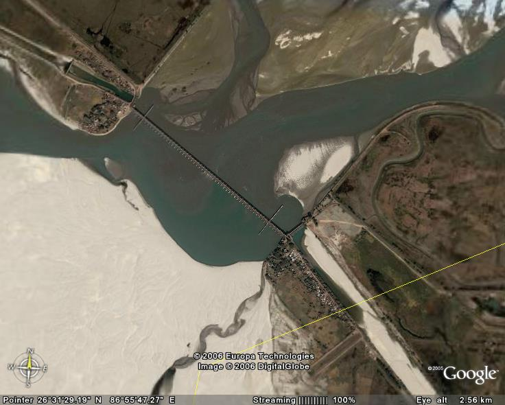
After the completion of the barrage at Hanuman Nagar in the year 1963 and completion of embankments both on upstream and downstream of the barrage, the tendency of the barrage for inducing siltation, particularly on the upstream in the silt pocket and the toe water was apparently evident. Because of the cross flows and the drifting of the silt along the cross-sections of the river even on down-stream, a general impression was conveyed by the silt deposits, particularly after the monsoon, that the river is showing a tendency of aggrading the bed.
Resolving the Kosi Flood Problem
Before discussing the long term & short term solution to Kosi flood problem, let us understand the philosophy, strategy and attitudes of Engineers & administrators regarding Flood problems.
Categorization of Flood
Flood problems can be broadly categorized into three types viz. Inundation, erosion of river banks and change of river course. Inundation:- It is the most common and the immediate impact of the floods as could be felt by all common citizens, can be caused by a number of factors such as excessive precipitation, inadequate channel capacity to carry the flood waters, obstruction in the stream, inadequate waterway at road and rail crossings or other encroachments aggravating flooding by causing afflux, congestion at confluence of rivers, lack of adequate proper drainage or by outside agencies such as tides resisting flood flows of rivers. Large tracts of cultivated and developed land with valuable properties and human habitation get affected due to such inundation putting at risk valuable lives of human beings and animals. Such flood problems create general panic amongst the people and necessity of resorting to immediate solution to ameliorate the hardships and dangers to the society is felt by everyone and suitable measures are immediately worked out and attended to by the concerned authorities. These are problems of emergent nature for which very little time is available when they arise, to sort them out on systematic engineering and scientific basis. These are, in fact, problems of emergent nature required to be fought with on war-footing, lest they may put the whole society and the administration at ransom. The flood problems are, therefore, basically understood at the first sight as problems of inundation only and other problems of floods which are in no way of less consequence are lost sight of because of their effect in general, felt after a long range of time.
Erosion of river banks and river bed: It adversely affects vast stretches of fertile developed agriculture land on the river margin or it may affect townships or urban concentration involving heavy damages to nature, vital communication links etc. In many a cases this problems of bank erosion posed by floods is felt more after the floods have receded rather than when the floods are actually in operation as is the case with the problem of denudation by sloughing with the result that its impact on the society is not felt immediately calling for emergent measures and so many times it is lost from sight of all the concerned authorities, especially when the rate of erosion is not remarkable or is of any such a magnitude as to endanger the safety of some important structures like embankments, protecting important townships. The problem of bank erosion during floods in latter case becomes more serious than the problem of inundation, as of erosion, if remains unabated, may result in heavy losses of property and life. Flood fighting measures are put on operation but many times they do not provide adequate or timely to stand against the fury of the floods.
Changes of river courses: It is the most complex problem created by the floods. Instability in the upper reaches of the river basins can accentuate the operation of the erosion factors, particularly while flowing through erodible sandy strata, thus increasing the sediment charge in a river, even without abrupt variations in bed gradients or heavy sediment charge, rivers sometimes develop tendency in changing their course to join a neighboring stream. These are cases of avulsions . Another category of change of river course, particularly in braided river channels is typified by oscillary beds, where the river emerging from a gorge swings from side to side in the flood plain within more or less specified limits, at times between the two nodal points. Such changes do not occur normally within a period of a year or two so as to draw the attention of the administrative authorities and to make the people feel the impact of such slow changes. Such changes in the river courses occur during the long span of years, as it happened in the case of river Kosi which change its course by about 115 kms in 250 years. Erosion of banks, conveying the sediment loads, drifting of the silt deposits, erosion of the beds, embayment of banks, change in the flow directions, creation of meanders and cut-offs ultimately result in the change of the river flow from one channel to another forms a phenomenon that occurs over a long period covering series of years.
Approach to tackle problems
Whereas various short term and emergent measures have already been considered and even implemented as an emergent measures on warfooting at times, for the first problem of floods, viz. inundation, a long term approach which can be practically implemented to yield some results in the reasonable short run, particularly with a view to minimise, if not possible to eliminate totally. If the primary root of creating this problem could be taken care of i.e. if the flow of water emerging from river’s origin or in the initial ranges could be checked positively, that may be an ideal condition towards the solution of the problem. The experts have considered this as a long term measure for problems of floods created by the rivers like Ganges, Brahmaputra and their tributaries. Various engineering methods of physical control with these aims in mind such as constructing storage reservoir on the river, detention basins, channel improvements, diversion of flow, raising habitations above flood level, demarcating flood prone areas and prohibiting further habitation and development there and water shed improvements, have been given thought of and wherever possible attempts have been made also to implement or try some of them. These measures, however, are not found in general to be within the economic range when kept exclusively for flood control unless they are associated with other provisions and benefits such as irrigation, power generation etc. These measures aim at physical control over floods which in reality is an herculian task. Better practical approach, therefore, would be to aim at reducing or redistributing the resulting flood damage. The non-engineering measures are of land development measure, soil conservation in catchment area of rivers but this is effective if carried out extensively in catchment area, as it helps in reducing a sediment load in rivers and this tends to make them less liable to change or erode their banks. This is however a very remote measure very difficult to achieve in reasonable time with cogent results.
The next alternative, therefore, remains to live with the water in the river but to allow it to flow in a manner, condition, size and pattern which would minimise, if not totally eliminate, the eroding characteristics of the channel/river and avulsions or oscillating trend of the river. This is the the practical solution, though requiring patience and preseverence by diligent studies over a number of years and in fact this is the only long term measure for solution of the second category of the flood problem. This requires study of understanding of the texture, structure and behavious of the river. It requires the study of topography, geology, geomorphology, meteorology and ecology of the basin of the river to arrive at a solution which is acceptable to all the authorities involved for development of the basins.
Once the river has reached or has approximate approach to such a situation the yearly damage and the recurring expenditure would be minimized to great extent. It will also ensure a proper navigation channel with adequate draft and the width. This can be used as a means of communication more smoothly and assuredly.
Solutions to Kosi Flood Problem
Keeping above aspect in view, we can suggest to have provision of dams in the drainage area with very big storage volume as the reasonably lasting solution to the Kosi flood problem to start with. With the construction of Kosi High dam, majority of detrimental silt would get trapped in the reservoir which would make this more docile and streamlined resulting therefore less meandering of river downstream of Chatra. We can draw similar lessons from China’s experience. China had both depended on and dreaded its mighty rivers. It is reported in CHINA DAILY that during the Qing Dynasty (1644 – 1911), control of the Yellow River was thought critical to dynastic stability. So a ministerial post – Governor of Yellow River Affairs – was established. The holder of this post was only second in power to the prime minister. Over the years sedimentation had raised the Yellow River bed by 5 – 10 centimeters a year. The riverbed in the lower reaches was elevated by 3 – 5 meters above the level of surrounding fields. The Yellow River had thus become a “hanging river”. Until recently there were on an average two breaches of the dikes every three years, and a major change of river course once a century. The centuries old China’s Yellow river flood problem has been resolved. China built several storage dams to control the Yellow river floods.
The other measures like Comprehensive catchment Area Treatment, training of rivers afer conducting the morphological studies should also go hand in hand as the dam alone can be effective for a limited period of its life say 100 years or 200 years. We have to strive for a lasting solution to this problem to make our future generation also safe and secured.
Conclusions
The phenomenon of recurrent floods in river Kosi coupled with shifting tendency of the river course is a natural corollary to the flow regime of the Kosi river system. Long term solutions aimed at managing these trends should be in synergy with the hydraulics of the river system. This should involve exhaustive studies in understanding the morphology and hydraulic characteristics of the river and demographic, geologic characteristics of the catchment area being drained by it. A single solution mindset may not be technically sound as it may not address the whole spectrum of disciplines involved and may ultimately fail on the yardstick of project-economics. Conceiving a multipurpose project in the upstream reaches of the river with large storage reservoir is being studied as an important measure towards achieving these objectives. These steps should be given an impetus at the highest levels of the government and should not be mired in unnecessary controversies lest the academic value of the study is lost.
References:
1. Feasibility Report of Sapta Kosi High Dam Multipurpose Project, Central Water Commission ( 1981 )
2. Morphological Studies of River Kosi, Central Water Commission (1985)
3. Bengal Census of 1981
4. A.B.Thapa, Spotlight (2006)
5. Reconnaissance Report of Central Waterways and Navigation Commission (1946)
6. POT ( 2004) : Weekly Opinion Magazine of South Asia
7. Master Plan of Kosi basin ( 1985): A Study by JICA for Government of Nepal
Disclosure
This paper was originally written by Awadhesh Kumar Jha and D.P. Mathuria while both were serving as Deputy Directors in the Central Water Commission. It is republished here as an archival piece with a present-day “Looking Back” note; the original paper has otherwise been retained substantially as written. The views in the original paper are those of the authors and do not represent the Central Water Commission or any organisation with which either author is currently associated.


Leave a Reply